- Home
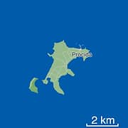
- Map of Procida
Map of Procida
Procida is the smallest island in the Bay of Naples, covering just 3.7 square kilometers (1.4 square miles). The other two main islands in the bay are much larger, with Capri covering 10 square kilometers (3.8 square miles) and Ischia covering 46 square kilometers (17.7 square miles).
There are 16 kilometers (10 miles) of rocky coastline, but the inland countryside of the island is more or less flat. The highest point is the medieval hamlet of Terra Murata, set 91 meters (300 feet) above sea level.


Procida is located 3.5 kilometers (2.2 miles) from the mainland (from Monte di Procida) with a bridge linking the island to the neighboring islet of Vivara.
The island has volcanic origins and is part of the geological area of the Phlegraean Fields. Its geothermal activity is the reason behind its dark-sand beaches as well as the yellow tufa stone and grey rock that make up most of the island.
Procida's main town is divided into nine districts, known as "grancìe": Terra Murata (the oldest settlement, dating back to the Middle Ages), Corricella (the fishing village known for its colorful houses), Sent'cò (the Marina Grande port where ferries dock), San Leonardo, Santissima Annunziata (also called Madonna della Libera), Sant'Antuono, Sant'Antonio, and Chiaiolella (the harbor located on the south side of the island).
How to Get Around Procida
Where to Stay on Procida
Ischia or Procida?